Registering a Nature Investment Zone
Nature Investment Zone Criteria
Nature Investment Zones (NIZs) are the key component of SNN, where scaled nature recovery can be kickstarted. They need to be at least 10,000ha in size and have substantive nature-based solution and ecosystem service potential.
To be featured as a potential NIZ an overall area boundary will need to be provided encompassing the following elements as mapped by the NIZ team in question and provided as polygons:
First phase NIZ Terrestrial NIZ Mapping
- The Core Zone – high biodiversity value land and sea – some of which may already be legally protected for its ecological value. This Zone will build on the International Finance Corporation’s Definition of Critical Habitat4 and the DEFRA definition of Areas of Particular Importance to Biodiversity (from the Local Nature Recovery Strategies) for designations of national and local value.
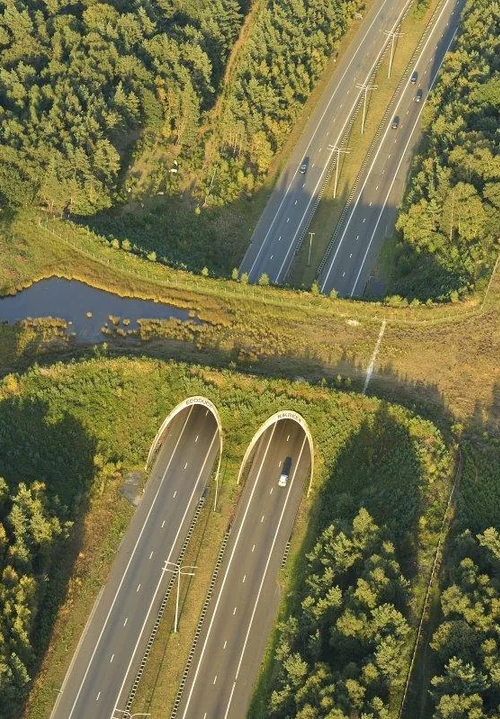
- The Restoration Zone – land, or sea, to be prioritised for nature restoration due to its location and potential for applying the Lawton Principles. Specific attention will be paid to critical landscape connections and ensuring this zone is both realistic and substantial enough to meet the 10,000ha size requirement of a NIZ. This will include recommendations for areas of national priority for green bridges.
- The Buffer Zone – areas where nature friendly farming should be encouraged to ensure ecological coherence in the NIZ, and to make sure it meets the minimum size requirement of 10,000 ha. Development should be minimised in this area as it would reduce the overall value of the NIZ and the SNN (socially and economically) through limiting connectivity and climate adaptation. This can overlap with the Restoration Zone.
- The Growth/Investment Zone – areas of development, business and industry where funds are generated through mandatory mitigation (biodiversity net gain, nutrient neutrality) and voluntary measures (carbon and biodiversity credits) to be channelled into NIZ investment projects.
Marine NIZ Mapping
Initially these should be confined to MPAs that adjoin terrestrial NIZs and/ or could be linked as classified by being more than 10Km from shore and therefore represent feasible connections near-coastal restoration activities.
These criteria will be checkable/ selectable through drop-down boxes and checkboxes (as below) to enable initial qualitative analysis by those submitting to check that their suggested areas meeting the RBN requirements.
Primary criterion = size:
- Confirmation that current and/ or potential size of habitat to be protected/ expanded up on, or restored from low ecological condition to high ecological condition exceeds 10,000Ha/ 10km2.
- GIS upload/creation system for polygon of overall area boundary.
Second Stage NIZ Modelling:
Modelling will be undertaken for each NIZ to indicate the potential earnings from Recovery Zone sites from various Nature based Solutions (NbS) finance streams – carbon, biodiversity net gain and (where appropriate) nutrient neutrality.
This work will be extended to existing high nature value land and sea in terms of quantifying the ecosystem services that they are already delivering both locally and – through aggregation via standard methodologies – regionally and nationally. These are areas where future ecological, social and governance (ESG)/voluntary biodiversity payments may well be particularly suitable.
Each NIZ should have an accompanying defragmentation plan, which builds on the connectivity mapping and landowner engagement to identify priority areas to improve connectivity across the landscape.
This modelling, alongside the NIZ delivery group’s knowledge of landowners, should allow for a shortlist of sites to be drawn up that could work as potential NbS projects to improve the NIZ’s biodiversity, connectivity and economy.
Defragmentation Mapping
Connectivity analysis will be by the RN technical team at the back end of the website to identify the optimal connection points between NIZs as they are submitted.
This will also be displayed, giving clear strategic targets for new national conservation initiatives.
The connectivity analysis will focus on national bottlenecks. There are two options which we will pursue. Either identifying national bottlenecks in connectivity without accounting for the existing projects, essentially giving theoretical priorities, or using a national map of habitat permeability to determine the least cost path between two major project, giving the most logical connections between the RN projects.

Strategic Nature Network Map
These registrations will build the Strategic Nature Network (SNN) model in to demonstrate the scale of deliverable ambition there is now across the UK, and where investment is required to safeguard (protection) or secure (restoration) these.
The NIZs will also be used to identify where landscape connectivity needs to be maintained (protection linked to the LNRS) or created (via ecological restoration of habitat and physical reconnection/ defragmentation across man-made infrastructure).
View the SNN Map
